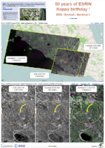
ESRIN, ESA’s centre for Earth observation in Frascati, near Rome (Italy), is one of the agency’s main specialised centres in Europe - its founding ceremony took place 50 years ago on 27 September 1968.
(source https://twitter.com/esa_history)
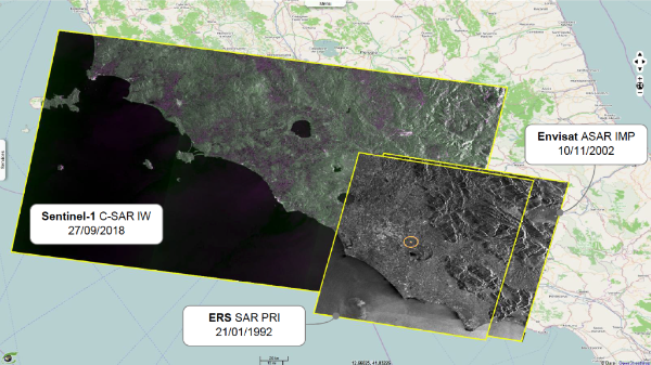
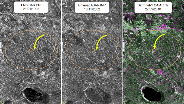
Earth observation in the radar domain is one of the first scientific skills of ESA. Three major mission series (ERS, Envisat and Sentinel-1) have produced thousands of scenes among which ESRIN site has been seen by:
ERS - 431 products PRI from 21.01.1992 to 02.05.2010
Envisat - 297 products IMP from 10.11.2002 to 31.03.2012
Sentinel-1 - 525 product IW from 07.10.2014
.
Fig.1: ESRIN seen from radar missions in 2D - Global view. 2D_Global_view
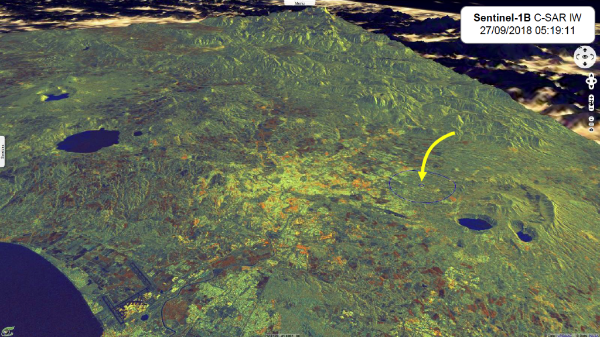
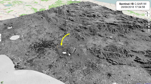
Figures 3 and 4 enable to compare the geometry of the Sentinel-1 scenes acquired in descending orbit and in ascending orbit respectively. Local time is CET, i.e. 2 hours later than the observation date/time expressed in Coordinated Universal Time (UTC).
In VtWeb, Sentinel-1 products are precisely orthorectified using a on-the-fly processing based on the physical model of observation (zero-Doppler retrieval, orbit interpolation, intersection with SRTM elevation model…).
Colour composition in fig.3 involves the two polarisations (VV and VH mapped on red and green planes respectively) and a “Normalised Difference Index” computing the (VH-VV)/(VH+VV) ratio and mapping it on the blue plane in order to enhance the difference between the two polarisations.
Fig.4 is a simple greyscale representation of the VV polarization only. Values are inversed to reinforce the impression of relief.
Fig.3: ESRIN seen from Sentinel-1B on 27.09.2018 (descending orbit) - VV,VH,NDI(VH,VV) - Elevation x2. 3D_view
Fig.4: ESRIN seen from Sentinel-1B on 28.09.2018 (ascending orbit) - VV - Elevation x2. 3D_view
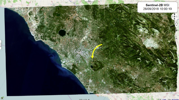
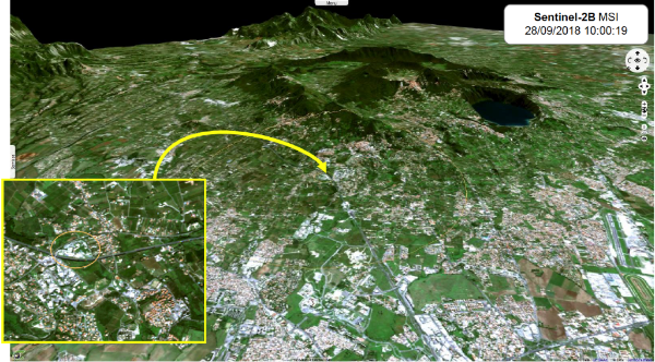
ESRIN seen from Sentinel-2
The Sentinel-2 mission is the first high-resolution optical mission designed for operational usage. Sentinel-2 multispectral instrument (MSI) inherits the experience from the Landsat and SPOT missions by improving the characteristics in terms of number of spectral bands (13 bands), spatial resolution (10m, 20m and 60m), swath width (290 km), and revisit time (5 days using both Sentinel-2A and Sentinel-2B missions).
Products are delivered by tiles of 100 km x 100 km.
.
Fig.5: ESRIN seen from Sentinel-2B on 28.09.2018 (2 tiles) - Natural colours (4,3,2) - Elevation x2 - Global view. 2D_view3D_view
Fig.6: ESRIN seen from Sentinel-2B on 28.09.2018 (2 tiles) - Natural colours (4,3,2) - Elevation x2 - Zoom on Frascati. 2D_view3D_view
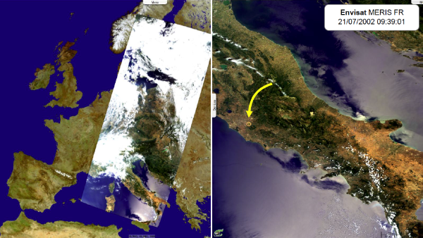
ESRIN seen from Envisat MERIS
and from Sentinel-3 OLCI
The Sentinel-3 mission has three instruments on-board: OLCI, SLSTR and SRAL. Sentinel-3 OLCI (Ocean and Land Colour Instrument) directly inherits the experience of EnvisatMERIS instrument.
OLCI is a spectrometer of 21 bands which wavelengths are in the range [0.4,1.02] μm. Instrument is an assembly of 5 cameras operating in pushbroom mode. The total swath width of 1270 km results from a field of view (FOV) of 68.5° tilted of 12.2° westward to minimise the risks of Sun glint. Products have a ground sampling distance (pixel size) of 300 m.
.
Fig.7: ESRIN seen from Envisat MERIS on 21/07/2002 - Natural colours (8,5,2). 2D_view3D_view
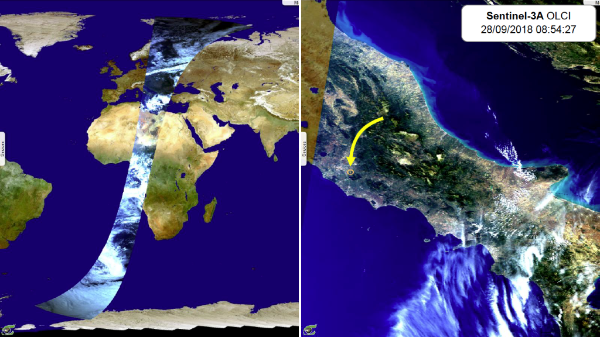
Fig.8: ESRIN seen from Sentinel-3A OLCI on 28.09.2018 - Natural colours (10,6,3) - RR (left) and FR (right). 2D_view3D_view
ESRIN seen from Sentinel-3 SLSTR
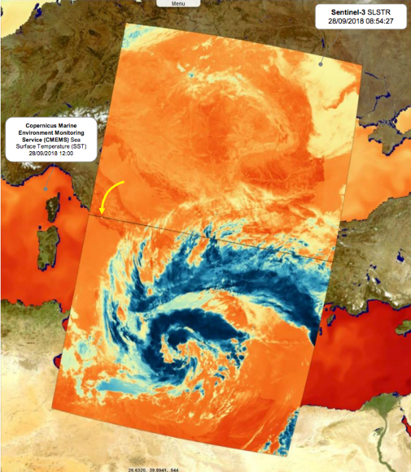
The Sentinel-3 mission has three instruments on-board: OLCI, SLSTR and SRAL. Sentinel-3 SLSTR (Sea and Land Surface Temperature Radiometer) directly inherits the experience of EnvisatAATSR instrument.
SLSTR is a dual conical scanning radiometer enabling to view points of the central swath at Nadir (vertical of the satellite) and backward. This dual viewing of a same target enables to compute atmospheric corrections by analysing the different paths through the atmosphere. Dual viewing is performed with a swath of 740 km while Nadir viewing is performed with a swath of 1400 km. SLSTR radiometer has 9 bands: -3 VIS 500m, -3 SWIR 500m, -3 MWIR/TIR 1km.
.
Fig.9: Sentinel-3A SLSTR on 28.09.2018 - S8 Nadir (Thermal, 10850 nm) - Over CMEMS SST model on 28.09.2018. 3D_view
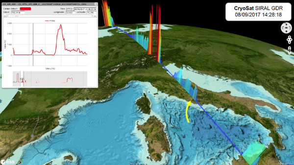
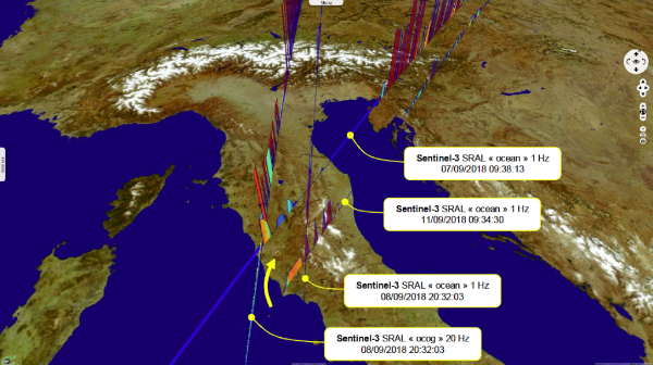
Cryosat SIRAL & Sentinel-3 SRAL
around ESRIN
The Sentinel-3 mission has three instruments on-board: OLCI, SLSTR and SRAL. Sentinel-3 SRAL (Sentinel-3 Ku/C Radar Altimeter) directly inherits the experience of ERSRA, EnvisatRA2 and CryoSatSIRAL instruments.
SRAL operates in two modes :
LRM (Low-Resolution Mode) - being the conventional mode by emitting (3 Ku / 1 C / 3 Ku) successive sequences,
SAR (Synthetic Aperture Radar) - being the mode with the highest spatial resolution by emitting 64 pulses in Ku-band framed by 1 pulse in C-band.
Les opinions exprimées dans ce document reflètent uniquement les résultats des travaux et l'opinion de VisioTerra.
The views expressed herein reflect solely the results of the works and the opinion of VisioTerra.